Comprehensive Plan
Prepare an integrated, implementation-oriented comprehensive plan for Bluefield that can proceed through staff review and the Town's public adoption process.
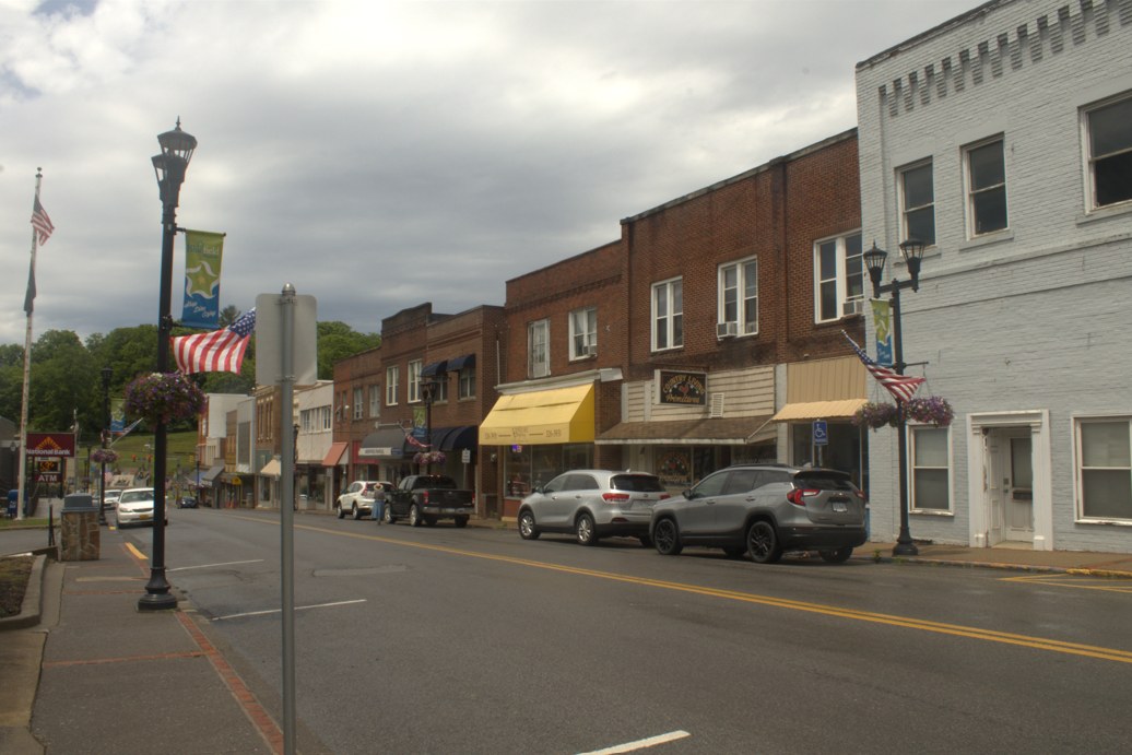
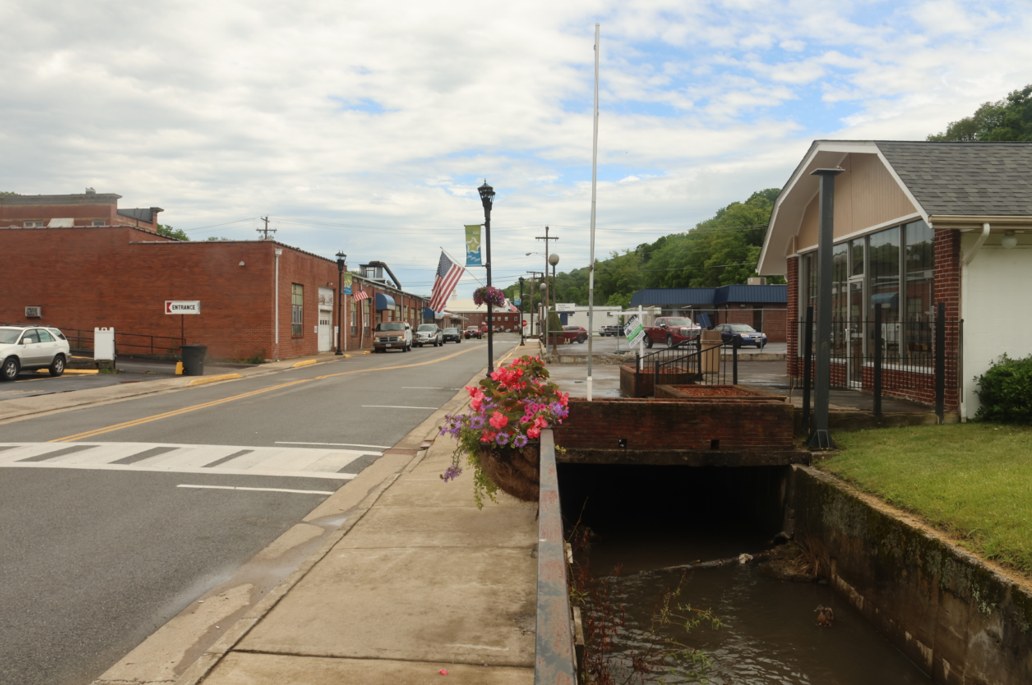
Additional field photographs
These instructor-provided photo albums offer additional context for the project area. Open them in a new tab.
- Bluefield field photo album Additional instructor-provided photographs of Bluefield, Virginia.
Community driving tour
Bluefield driving tour
This driving tour begins near Bluefield's southern outskirts and continues northeast through the town toward its suburban commercial area. Because the tour was recorded during a rainstorm, visibility varies along portions of the route.
Watch the GoPro tourProject purpose
Bluefield asked the class to help prepare a new comprehensive plan for Bluefield, Virginia that follows Virginia law and can move toward local review and adoption. The work should use the Town's existing plan and records, relevant neighboring context from Bluefield, West Virginia, and focused public input. The Town also identified GIS support, a sidewalk inventory, zoning and subdivision code assistance, chapter-by-chapter design and color bars, available water-line mapping, sanitary-service coordination, and Bluefield University coordination as useful parts of the effort.
Scope of work
- Review Virginia comprehensive-plan requirements and synthesize Bluefield's existing plan, ordinances, maps, studies, current initiatives, and relevant neighboring plans.
- Document existing conditions and community priorities through focused public engagement, GIS, sidewalk information, available utility context, and coordination with Town staff and Bluefield University.
- Prepare the plan structure, chapters, maps, graphics, chapter color system, implementation actions, and carefully bounded zoning and subdivision code assistance agreed upon with the Town.
Expected deliverables
- A documented review of existing plans, conditions, community input, and statutory requirements
- An integrated draft comprehensive plan with chapters, maps, graphics, chapter color system, and agreed code-support material
- An implementation program, staff-review revisions, final course draft, and organized editable files for the Town
Case studies and precedents
These examples can help you see different ways the work has been done. Treat them as starting points, not prescriptions. Check what is specific to each place and what still needs evidence for your project.
Wytheville, Virginia
One Wytheville Comprehensive Plan
The current plan project brings together the adopted 2013 plan, housing and transportation studies, downtown redevelopment work, and public input in one long-range planning process.
What to study: See how focused studies can inform a town-wide plan without becoming separate plans with competing directions.
Context: Separate adopted policy from current draft and project materials.
Vinton, Virginia
Vinton 2050 Comprehensive Plan
A recent small-town Virginia plan connects community story, land-use policy, maps, transportation, and public investment.
What to study: Trace how the plan turns community evidence into goals, policies, mapped choices, and implementation.
Context: Use it as a structure example. Bluefield needs its own evidence, choices, and legal review.
Bluefield, West Virginia
Bluefield 2025 Comprehensive Plan
The adjacent city has a recently adopted plan that can be compared for document organization and the path from community priorities to implementation.
What to study: Compare the plan's chapter logic and implementation format with what the Virginia Town needs.
Context: This is a separate city and state. Do not transfer its legal framework, policies, data, or recommendations into the Bluefield, Virginia plan.
Scope and review parameters
- Bluefield, Virginia is the client and legal planning jurisdiction.
- The assignment includes sidewalk, water-system, sanitary-service, university, zoning, subdivision, and public-engagement work only to the extent supported by available information and staff direction.
- Town staff control public release, formal review, and the adoption process; draft material remains working material until approved for release.
Treat the list above as the client's full set of needs, not a promise that every item will be completed this semester. In the Work Plan, commit to approximately 50% of what the team is confident it can complete well by the final deadline. The committed scope must be approved by the instructor and client. Additional work may be completed if time and evidence allow. All public claims, utility information, maps, and draft policy language must be traceable to a source and cleared for the intended use.
Comparable places
Global Twins
These places face comparable terrain, settlement or economic challenges. Study the documented response, the conditions it depends on, and what differs here. A close analogy is a basis for analysis, not a design to copy or a claim about ancestral origin.
Explore the map and all comparisonsBluefield, Virginia
A mountain town with rail heritage, a regional-service role and an adjoining jurisdiction across a state boundary.
Europe
Blaenavon
Torfaen, Wales · United Kingdom

Upland South Wales industrial town within a broad coal-and-iron cultural landscape, with mines, ironworks, transport infrastructure, workers' housing, and surrounding upland landforms.
Population: Town population not stated in the current sources cited; older UNESCO-linked source reports approximately 6,000 circa 2000, not a current estimate
What happened here
Big Pit National Coal Museum operates guided underground tours in the preserved mine. Separately, Torfaen's Townscape Heritage Programme completed a £1.9 million town-centre heritage regeneration project in March 2025. The UNESCO property management system coordinates conservation, planning controls, interpretation and visitor management. No unverified visitor, employment or regeneration-success totals are asserted.
Why compare it with Bluefield, Virginia?
A close analogue for the combination of a small Appalachian town, coal/rail history, historic downtown fabric, and the need to connect heritage assets to present-day regeneration. Similarity is functional and historical, not a claim of identical scale or institutions.
- mountain or upland setting shaped industrial settlement
- coal extraction and rail/industrial infrastructure influenced town development
- historic downtown and worker-built fabric remain visible assets
- economic transition requires linking heritage conservation with community regeneration
What students should study here
- Use a coordinated landscape-scale plan that connects downtown buildings, industrial sites, transport remnants, and the surrounding terrain.
- Pair heritage reuse with everyday community functions, skills, and local business activity; visitor facilities alone are insufficient.
- Use a partnership across municipal, heritage, museum, community, and land-management bodies.
- Protect views and setting while evaluating new development and reuse proposals.
What differs: Blaenavon's UNESCO-listed property is a 3,310-hectare landscape with ironmaking and coal mining from the Industrial Revolution; Bluefield, Virginia is an incorporated American town shaped by late-19th-century railroad/coal growth. Do not substitute Bluefield, West Virginia.
Virginia project contextSources and geographic scope
Checked September 30, 2026. Population figures retain their year and statistical boundary; a municipal total is not a village count. Locator points are approximate, not surveyed boundaries.
- Blaenavon Industrial LandscapeUNESCO World Heritage Centre
- Blaenavon management-plan case studyUNESCO World Heritage Centre
- Blaenavon regeneration historyVisit Blaenavon / local partnership information
- Bluefield Commercial Historic District nominationVirginia Department of Historic Resources / National Register nomination
- Big Pit National Coal Museum underground tour
- Blaenavon Townscape Heritage Programme
Blaenavon: Approximate named-place locator, not a survey, parcel or settlement boundary. Coordinate source
Europe
Anina
Caraș-Severin County, Banat · Romania

Mountain town in Romania's Banat region with a coal-mining industrial heritage and a local government strategy platform that includes an integrated urban development strategy to 2030.
Population: 5,521 (resident population, 1 December 2021; Anina town UAT including component localities)
What happened here
CFR Călători operates the Oravița–Anina route as a tourist rail service; its tariff effective 14 December 2025 describes the 33 km mountain route and required seat reservations. A local integrated territorial strategy also identifies rehabilitation of Anina station and the Oravița station area as gateways in a multi-town cultural/industrial route. Station rehabilitation is planned work, not a claimed completed project.
Why compare it with Bluefield, Virginia?
A coal-legacy mountain town with an explicit local development strategy is a useful comparator for Bluefield's transition planning, especially for how to frame diversification and place assets; strategy statements are plans, not proof of completed outcomes.
- mountain town with coal-mining legacy
- industrial employment history shapes identity and redevelopment needs
- town-scale strategy can connect infrastructure, services, and economic diversification
- heritage and nature-based attractions are considered as economic assets
What students should study here
- Translate a broad strategy into named, costed actions with lead agencies, funding sources, and measurable milestones.
- Treat mine heritage and trails as one diversification strand rather than assuming tourism alone replaces lost employment.
- Build partnerships with other former mining regions for technical exchange, while testing transferability locally.
What differs: Anina is in Romania and its SIDU 2030 is a stated strategy; this evidence does not establish which actions are funded or completed. Bluefield, Virginia has distinct U.S. governance, rail, and labor-market conditions.
Virginia project contextSources and geographic scope
Checked September 30, 2026. Population figures retain their year and statistical boundary; a municipal total is not a village count. Locator points are approximate, not surveyed boundaries.
- Anina City Hall: programs and strategiesPrimăria Orașului Anina
- Romania 2021 Census definitive results, Table 1.03Institutul Național de Statistică (INS Romania), official census results portal
- Anina proposed mayoral programCandidate-authored program; not municipal policy or verified implementation
- CFR Călători Oravița–Anina tourist tariff and service
- Integrated territorial strategy for Microregion Banatul Montan
Anina: Approximate named-place locator, not a survey, parcel or settlement boundary. Coordinate source
Europe
Blaenau Ffestiniog
Gwynedd, Wales · United Kingdom

Upland slate-mining town in the Ffestiniog component of the Slate Landscape of Northwest Wales serial World Heritage property; quarry workings, railways, settlements, and transport routes form one landscape.
Population: 3,763 approximate Census 2021 built-up-area estimate, summed from census output areas assigned to ONS BUA W45000158; ONS does not present this derived sum as an official exact population count and boundary alignment may be imperfect.
What happened here
Gwynedd's regeneration programme links the Blaenau Ffestiniog Community Destination Plan to town-centre regeneration and linking local attractions. Current visitor products include Ffestiniog Railway services to Blaenau and Llechwedd's guided Deep Mine Tour and slate-cavern adventure activities. The Slate Landscape plan sets specific community destination, interpretation, and visitor-management actions. These are documented programs, not proof of community-wide economic gains.
Why compare it with Bluefield, Virginia?
A strong industrial-town comparison for how a small upland community can interpret a former extractive economy as a linked landscape of town, mine, transport, and work culture.
- upland town shaped by extractive industry
- industrial transport corridors connected work sites to markets
- historic town fabric is part of a wider industrial landscape
- post-industrial identity and economic diversification are ongoing planning concerns
What students should study here
- Plan at landscape scale while preserving the distinct role and needs of the town centre.
- Link trails, transport heritage, industrial sites, and living community destinations into a coherent offer.
- Use formal setting and views protections when assessing energy, infrastructure, or new development proposals.
- Keep resident needs and Welsh-language/community identity visible alongside visitor interpretation.
What differs: The listed property is specifically the Slate Landscape of Northwest Wales, not a Blaenau-Ffestiniog-only UNESCO site. Its slate-quarrying, Welsh-language, and regional planning context differs from Bluefield's coal/rail history.
Virginia project contextSources and geographic scope
Checked September 30, 2026. Population figures retain their year and statistical boundary; a municipal total is not a village count. Locator points are approximate, not surveyed boundaries.
- The Slate Landscape of Northwest WalesUNESCO World Heritage Centre
- UNESCO in the UK: Slate Landscape factsheetUK National Commission for UNESCO
- UNESCO decision 44 COM 8B.47UNESCO World Heritage Committee
- ONS Census 2021 built-up areas datasetOffice for National Statistics; town count reproduced by censusdata.uk from census output areas
- Cyngor Gwynedd Blaenau Ffestiniog regeneration
- Ffestiniog and Welsh Highland Railways 2026 train services
- Zip World Llechwedd Deep Mine and quarry activities
- Blaenau Ffestiniog Community Destination Plan
- Slate Landscape of Northwest Wales Management Plan
Blaenau Ffestiniog: Approximate named-place locator, not a survey, parcel or settlement boundary. Coordinate source
Europe
Banská Štiavnica
Banská Bystrica Region · Slovakia

Historic mining town set on steep slopes in the Štiavnické Vrchy, surrounded by mining, metallurgical, and water-management works within a UNESCO property of 20,632 hectares.
Population: 9,628 (town, 2021 census)
What happened here
The 2023 update to Banská Štiavnica's UNESCO management plan is a landscape-wide framework for protection and contemporary use of the mining heritage; UNESCO identifies the historic water-management system and reservoirs (tajchy) as core attributes. The Slovak Mining Museum operates guided underground exhibits including the Open-Air Mining Museum and Glanzenberg Mine. The Mining Academy began in the 1760s and ceased in 1919; it is historical heritage, not a current university in Banská Štiavnica.
Why compare it with Bluefield, Virginia?
A close analogue for mining legacy embedded in both downtown form and surrounding infrastructure, and for using an adopted management framework to coordinate conservation, new uses, and regional development.
- historic mountain town whose growth depended on mining
- industrial and technical infrastructure remains legible in the wider landscape
- economic change followed the decline of mineral extraction
- heritage protection must be coordinated with viable contemporary uses
What students should study here
- Maintain a current management plan with an action plan, protection tools, condition monitoring, and named partner roles.
- Inventory industrial systems beyond landmark buildings, including water, transport, and settlement relationships.
- Seek adaptive uses for technical monuments while retaining authenticity and integrity.
- Coordinate town planning with protected landscape and surrounding municipalities.
What differs: Banská Štiavnica is a medieval precious-metals centre with a sophisticated historic water system and UNESCO World Heritage status; Bluefield is a U.S. coal/rail town. The Slovak statutory and UNESCO framework cannot be assumed transferable.
Virginia project contextSources and geographic scope
Checked September 30, 2026. Population figures retain their year and statistical boundary; a municipal total is not a village count. Locator points are approximate, not surveyed boundaries.
- Historic Town of Banská Štiavnica and the Technical Monuments in its VicinityUNESCO World Heritage Centre
- Banská Štiavnica 2021 census resultsMesto Banská Štiavnica, reporting Statistical Office census result
- Strategic documentsMesto Banská Štiavnica
- UNESCO site management plan pageMesto Banská Štiavnica
- Slovak Mining Museum rules for underground exhibits
- Banská Štiavnica municipal history of schooling
Banská Štiavnica: Approximate named-place locator, not a survey, parcel or settlement boundary. Coordinate source
Europe
Puigcerdà / Bourg-Madame
Catalonia / Occitanie · Spain / France

Adjacent Catalan and French municipalities in the high Pyrenees and Cerdanya valley, divided by an international border but linked through formal intermunicipal and cross-border service cooperation.
Population: Separate units, not a combined total: Puigcerdà 10,041 residents (2024 provisional); Bourg-Madame 1,182 municipal population (2023 INSEE reference population)
What happened here
The Hospital de Cerdanya/Hôpital de Cerdagne is an operating cross-border health institution created through a European Grouping of Territorial Cooperation, jointly managed by Catalan and French administrations to serve Cerdanya and Capcir. The Puigcerdà–Bourg-Madame public-law cross-border consortium is a separate local cooperation instrument. These are concrete shared-service institutions; they do not imply identical health-law or funding conditions for U.S. state-border cooperation.
Why compare it with Bluefield, Virginia?
This is primarily a regional-governance precedent: two adjacent municipalities created formal cooperative structures to address shared services across a boundary. The relevance to Bluefield is coordination with Bluefield, West Virginia, not a shared coal-transition claim.
- adjacent communities are functionally connected across a jurisdictional boundary
- residents depend on regional-scale services and infrastructure
- formal intergovernmental agreements create shared delivery capacity
- mountain geography makes local and cross-border access important
What students should study here
- Define a narrow shared-service problem, then establish a durable intergovernmental instrument and decision process.
- Specify participating jurisdictions, service territory, financing, staffing, and accountability in the agreement.
- Keep each jurisdiction's population, authority, and obligations distinct while measuring shared service outcomes.
- Treat language, legal systems, insurance, and funding rules as design constraints, not details to resolve later.
What differs: Puigcerdà–Bourg-Madame is international and European, with distinct national law and cross-border governance; Bluefield, Virginia and Bluefield, West Virginia are domestic U.S. municipalities in different states. The precedent is cooperation mechanics, not a claim that a transnational health arrangement is directly replicable.
Virginia project contextSources and geographic scope
Checked September 30, 2026. Population figures retain their year and statistical boundary; a municipal total is not a village count. Locator points are approximate, not surveyed boundaries.
- Spanish Official Gazette: Puigcerdà–Bourg-Madame cross-border cooperation agreementBoletín Oficial del Estado, Spain
- Hôpital de CerdagneHôpital de Cerdagne / cross-border hospital administrations
- European Commission cross-border health cooperationEuropean Commission, DG Regional and Urban Policy
- INSEE Bourg-Madame geographyINSEE
- INSEE reference population 2023, Bourg-MadameInstitut national de la statistique et des études économiques
- Idescat population-linked estimates, PuigcerdàStatistical Institute of Catalonia
Puigcerdà: Approximate named-place locator, not a survey, parcel or settlement boundary. Coordinate source
Bourg-Madame: Approximate named-place locator, not a survey, parcel or settlement boundary. Coordinate source
U.S. Appalachia
Corbin
Southeastern Kentucky (Laurel, Whitley and Knox counties) · United States
Appalachian foothills city at the junction of multiple county and highway service areas. Rail yards and highway corridors shaped its growth; the surrounding regional economy includes manufacturing, logistics, and rural services.
Population: 7,856 (incorporated city, 2020 Census)
What happened here
The Kentucky Transportation Cabinet's 2025 Statewide Rail Plan documents a feasibility study by the Southeast Kentucky Industrial Development Authority for a potential intermodal facility on underused CSXT property in Corbin. The study is feasibility work, not an approved or built terminal. Corbin's 2015 comprehensive plan separately identifies two industrial parks with over 800 combined acres.
Why compare it with Bluefield, Virginia?
A railroad-shaped regional centre with a historic downtown and contemporary industrial land, where the rail legacy remains a planning asset but new rail use must be tested against current operations and demand.
- rail infrastructure influenced town formation and regional access
- small-city scale with an economic catchment beyond city limits
- historic downtown and industrial areas coexist
- transport assets and workforce access are part of diversification strategy
What students should study here
- Corbin's current intermodal feasibility study on underused CSXT property is a model for testing rail reuse before promising it.
- Coordinate industrial parks, rail yards, highways, and downtown land use as a regional system.
- Inventory tenant-ready sites and infrastructure constraints separately from historic rail assets.
- Work across counties where the effective labor market and service catchment cross municipal boundaries.
What differs: Corbin's documented industrial strategy includes two parks with more than 800 acres combined and a proposed intermodal feasibility study. Bluefield's coalfield history and Virginia governance context differ. Corbin's 2020 city count excludes a wider three-county trade area.
Virginia project contextSources and geographic scope
Checked September 30, 2026. Population figures retain their year and statistical boundary; a municipal total is not a village count. Locator points are approximate, not surveyed boundaries.
- U.S. Census Bureau QuickFacts: Corbin cityU.S. Census Bureau
- City of Corbin Comprehensive PlanCity of Corbin
- Kentucky Statewide Rail Plan 2025Kentucky Transportation Cabinet
- Corbin historyCorbin Tourism and Convention Commission
Corbin: Approximate named-place locator, not a survey, parcel or settlement boundary. Coordinate source
Canadian Appalachia
Campbellton
Restigouche County, New Brunswick · Canada

Small city on the Restigouche River in northern New Brunswick, near the Quebec boundary and within Canada's Appalachian Uplands physiographic region. It serves a broader rural area with forestry, tourism, and public/commercial services.
Population: Approximately 12,000 residents (new Campbellton municipality, 2023 budget statement; expanded boundary effective 1 January 2023). The 2021 Statistics Canada city count of 6,883 applies to the old city boundary and is not used as current expanded-city population.
What happened here
Restigouche Regional Service Commission reports completion and approval of the new Campbellton Regional Community municipal plan in its 2025 annual report. In June 2026, federal, provincial and municipal governments announced more than $1.1 million for water/sewer upgrades, including connecting distribution systems between wards. Public Services and Procurement Canada separately documented J.C. Van Horne Bridge bearing, erosion-protection and retaining-wall work coordinated with New Brunswick and Quebec traffic authorities. These are documented governance and infrastructure projects, not quantified growth outcomes.
Why compare it with Bluefield, Virginia?
A rail- and resource-linked northern Appalachian service centre with a regional catchment and post-industrial transition issues. Its current municipal boundaries were enlarged by reform, making governance scale itself an important transferable planning lesson.
- small regional city serving rural communities beyond its core
- Appalachian mountain/upland regional setting and river corridor
- historic resource and transport industries influenced local development
- regional service and employment role exceeds the old municipal footprint
- land-use and service coordination across neighboring communities is material
What students should study here
- Budget and plan at the new municipal/service boundary while preserving neighborhood-scale service data.
- Pair business diversification with realistic regional access, workforce, and year-round service strategies.
- Map the actual status and function of rail and port assets before treating them as operating freight capacity.
- Use regional partnerships to plan workforce, tourism, forestry value chains, and infrastructure.
What differs: Campbellton is a Canadian Francophone/Anglophone border-region city with a 2023 amalgamation that combined Campbellton, Atholville, Tide Head, and parts of local service districts. Its river and forestry/pulp economy differ from Bluefield's coalfield context. The ARC program does not include Canada.
Virginia project contextSources and geographic scope
Checked September 30, 2026. Population figures retain their year and statistical boundary; a municipal total is not a village count. Locator points are approximate, not surveyed boundaries.
- Campbellton 2023 budget announcementCampbellton Regional Community / municipal government
- Regulation 2022-50, Local Governance Reform ActGovernment of New Brunswick
- Statistics Canada 2021 population and dwelling countsStatistics Canada
- Atlas of Canada: Physiographic Regions of CanadaNatural Resources Canada / Geological Survey of Canada
- Restigouche Regional Service Commission 2025 annual report highlights
- New Brunswick funding for Campbellton water and sewer upgrades
- J.C. Van Horne Bridge
Campbellton: Approximate named-place locator, not a survey, parcel or settlement boundary. Coordinate source
Work from the confirmed scope.
Use the community conversation, instructor-provided project needs, and existing documents to keep your work aligned with the client. Confirm any scope change with Tyler before promising it to the community partner.
See all projects